

Next stop, about 5 minutes away, was the Costco to get breakfast groceries and evening snacks as we were going to be staying in a condo for the next four nights. The Costco was packed with shoppers - Kahalui is a hub for many of the 150,000 inhabitants of Maui. Traffic here is a miniturized version of Honolulu traffic; you need to pass through Kahalui to get just about anywhere, but it does not take too long and if you need to pick anything up, invariably you will find it in this town.
From the store, we set out for our condo in Kihei, a twenty minute drive away. I guess this is a good time to talk about driving in Hawaii. First, highway numbers are basically meaningless in Hawaii, as the same road tends to change numbers (and names) several times and for no apparent reason to us mainlanders. Most locals know the highways by name (e.g. Nimitz Highway, Hana Highway) if you need to ask directions. You can use a GPS (my Garmin worked fine) and ignore highway numbers and names. Second, speed limits tend to be much lower than on the mainland. It is rare to ever see 55 or more mph zones. Most of the time, the speed limit on main roads is 40 mph. Most roads do not lend themselves to faster speeds in any event and the pace of life in Hawaii (at least outside Honolulu) is much slower than the mainland. So people expect and accept the slower speeds. We only saw one crazy driver trying to pass everything on the road and that was on the Big Island. This pace of living is something to remember because service in restaurants is also slower than North Americans are used to. Hey, you are in Hawaii, so slow down and enjoy!
 |
| Kihei Condo |
We found our condo - or at least the building complex - and the boys went in to find the office to determine which of the buildings our unit was in. The office was closed, but an Indian restaurant beside it was open. I went inside the restaurant to see if they could shed any light on our unit, but to no avail. A passing person in the parking lot suggested a probably location, so we went up and found the unit which was the last one on the 5th floor in the right hand building. A few minutes later, we had loaded up our luggage and groceries into a couple of shopping carts we found on the ground floor and were settled in to our base for our Maui adventures. Although dark, we could tell we were looking out toward the ocean and a large mountain because either there was a cloud city a la Star Wars up there, or there was a large mountain with a town on it to the south of us.
 |
| Sunrise over Puu Kukui |
 |
| Start of Hana Highway |
The Hana Highway is a famous drive and a very popular tourist attraction. If I can give you any advice about the Hana Highway it is to GO EARLY. Despite beijng only 109 kilometres long, It takes several hours to drive to Hana from Kahalui and back; a whole day if you stop at only a few of the wayside attractions (It would take several days to see all the waterfalls, beaches, small villages and historical sites along this road). We left at 8:30 a.m., arrived in Hana at 1:30 p.m. and got back at 5 p.m. As we were returning, we encountered people coming towards us near the beginning of the Hana Highway (usually driving Mustang convertibles) late in the afternoon. These people were not going to make it there and back before dark. So now that you have been warned, let's go for the drive.
 |
| Hana Coastline |
Why does it take so long to drive 109 kilometres? Well, there is the gorgeous scenery as almost the entire drive takes place along the ocean in a tropical rain forest on the side of a volcano. As well, there are 620 sharp curves on the highway in that distance, 59 bridges of which 46 are one lane, and in many places, the highway is only one lane wide. The speed limit tops out at 25 mph and in many places, the limit drops to 10 mph. And it is busy; so busy that apparently in peak tourist months, it is bumper to bumper as more than 1000 cars a day drive to Hana. We did not have that problem in November, but there were quite a few tourist cars and SUVs, tourist buses (small ones) and the odd local person all heading out to Hana in the morning with most heading back in the latter part of the afternoon.
 |
| Looking down |
 |
| Far Out Windsurfers |
 |
| High on the Hana Highway |
 |
| Butterfly flowers? |
 |
| Water, water everywhere |
.jpg) |
| Honolulunui Bay |
.jpg) |
| Surf's Up |
 |
| Black Beach |
 |
| Black Beach Bug |
 |
| Ho'opika Surfer |
.jpg) |
| Sunset from Condo Roof |
We decided to take advantage of the fact we had a condo, so on the way through Kahalui, we stopped at the Costco to get gas and to pick up stuff to make dinner. Of course we also needed some more liquid refreshments for the evening and the next day for lunch so we filled up on these as well. When we got back to the condo, we watched the sun go down from the roof, then had a 'home cooked' dinner later that evening. After dinner, we sat out on the balcony, enjoyed a glass (or two) of wine and spent a pleasant evening as another beautiful day came to an end.
 |
| Gramma's House on Haleakala |
Haleakala is a massive shield volcano (as are all volcanoes in Hawaii) which means it was built from successive and multiple lava flows that flowed out in all directions from a central area, forming what looks like a warrior's shield when viewed from afar. It is so massive that fully 75% of Maui is made up of the volcano. It has, according to geologists, only erupted three times in the last 300 years, the last time in the 1700s so its days as an active volcano may be coming to an end.
 |
| Kihei, Plain, Sugar Mill, West Volcano |
To get to Haleakala (at least the summit) from Kihei, you have to go to Kahului which is north west in order to go south east on the Haleakala Highway. As you cross the plain between Haleakala and the West Volcano mountains formed when lava from two shield volcanos merged, you drive through fields of sugar cane. Sugar cane used to be Hawaii's main export, but now only one mill is still operational on Maui and the road goes right by it. The white smoke coming from the mill's stacks as the sugar syrup is boiled to evaporate the water can be seen from a long distance away, and if the wind is right, the sweet smell of boiling sugar is detectable on the breeze.
We stopped briefly in Kahalui at a grocery store to pick up a picnic lunch, having learned from the day before. Then, we pointed the SUV southeast towards the volcano in the distance. The first couple of kilometres of the Haleakala Highway (also called the Old Haleakala Highway and the Kula Highway) is actually a divided highway until the town of Pukalani. It is just on the edge of this town that you keep left on the Haleakala Highway which starts to climb slowly through trees. Just before the Highway becomes Kekaulike Avenue, we came to Crater Road which is also the Haleakala Highway. Confused yet?
 |
| Above the clouds on Haleakala |
As we were following the actual signs to the Haleakala National Park and my GPS and not road names or numbers, we were not confused by all the changes and turned left for our final climb up the mountain. As we began the climb, the road started to make switchback turns and the lava flows become visible as the road often cut through them. We were now in cattle country as evidenced by the cattle crossing grates on the road although we saw no cattle. Small copses of Koa and other trees soon gave way to open country. We passed a 'bicyle van' parked on the side of the road, several bikes parked in front of it. Lots of people (those who are very fit) ride up to the summit on bikes, but even more ride down and the van takes you up for the long coasting descent. As we climbed higher, the vistas down to Kihei and Kahului become more grand until eventually, we were driving through the clouds before evenutally rising above them.
 |
| Chukar |
Just after clearing a last copse of pine trees we came to the National Park entrance and paid our $10 entrance fee. We stopped at the visitor centre for a few minutes where we learned about the State bird, the Nene (pronounced nay nay) Goose. Found only on Maui, Kuai and Hawaii (Big Island) today, scientists believe it evolved from the Canada Goose which arrived in Hawaii around 500,000 years ago. One of the first Canadian tourists I suppose. The Nene is a very rare bird and although we saw lots of signs warning us to watch for Nene crossing the road, we did not see any. We had to settle for a Chukar, which is not even native to Hawaii, having been introduced from Asia in the 1920s.
 |
| Cinder Cone from Leleiwi |
 |
| The clouds roll in |
.jpg) |
| View from the summit |
.jpg) |
| Chip Balloon |
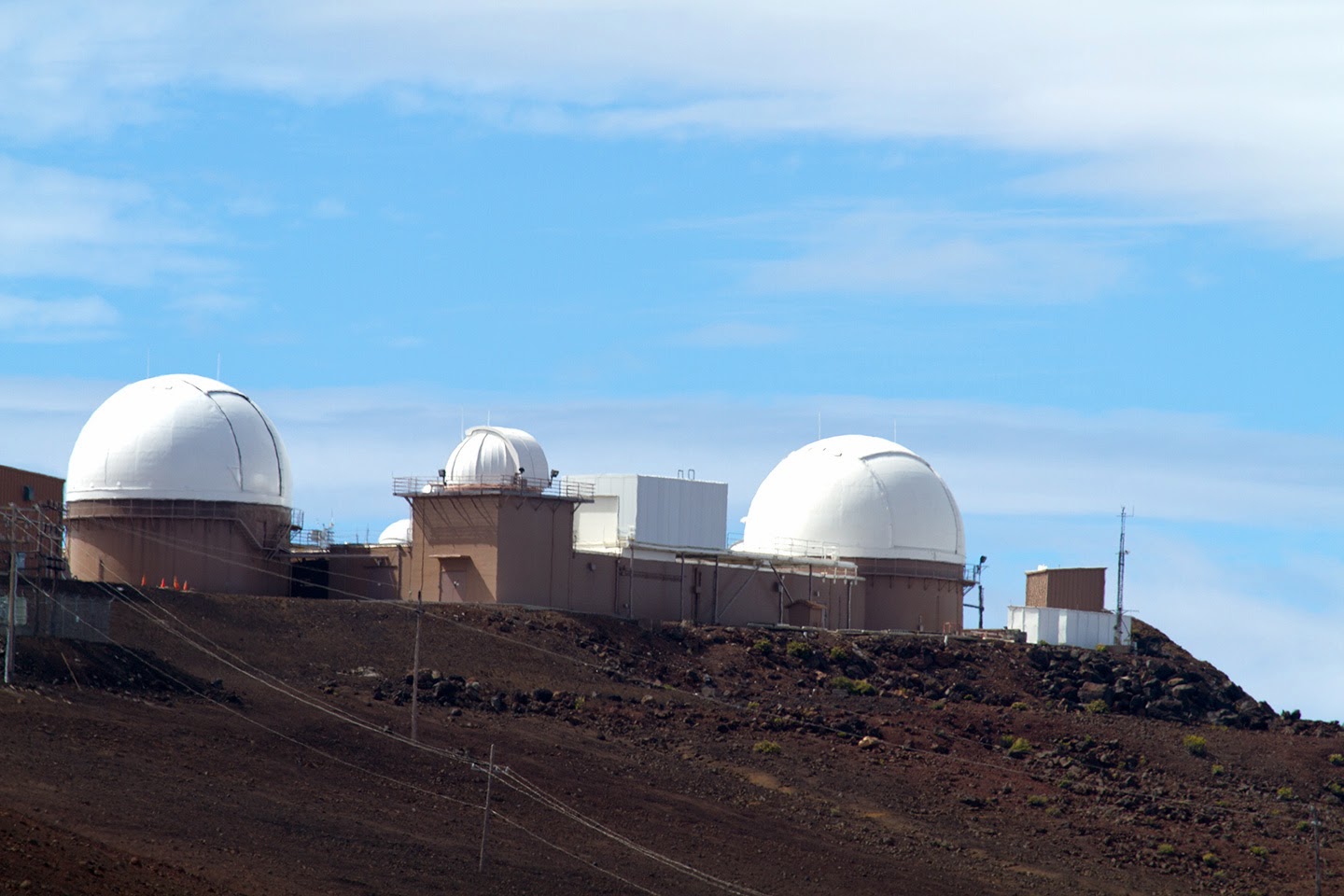 |
| Science City |
From the observatory, we could easily see the two volcanoes on the Island of Hawaii (Big Island) more than 150 km away to the south. Much closer at hand is Science City, the group of white observatories that is off limits to the public. Operated by the University of Hawaii, the Smithsonian Institute and the US Air Force, this is one of the most coveted places on earth for observing the night skies as there is very little light pollution and much of the thicker atmosphere lies below. While the Air Force tracks satellites for national defence purposes, the other partners observe the stars, planets and other astronomical phenomena.
As it was now noon, we decided to begin our trek back down the mountain to Hosmer Grove, a picnic area we had noticed near the park entrance on the way up, to have a picnic lunch. As we descended, we stopped at Kalahaku Overlook. While the parking lot was clear, just a few metres up the trail, clouds completed covered the view to the crater below and even covered the observation area in a light fog. So we continued down until we thought we were below the clouds and pulled into the road leading to Hosmer Grove. But we soon found out why the Grove exists as a pocket of rain forest, because as we pulled into this depression it started to rain. Thankfully, there was a covered table here which is where we sat and had our picnic lunch.
 |
| Hawaiian Cowgirl |
 |
| Shopping Directions |
As it was now getting on in the afternoon, we headed back to our condominium for refreshments. While having a dip in the pool, my sister-in-law and I got talking to a resident from the condo. She was studying to be a chef, so we asked her for a recommendation for dinner at a seafood restaurant. She recommended Longhi's in Wailea, a town about 10 kilometres south of Kihei. As a bonus feature, it was Wailea Restaurant week when restaurants, including Longhi's, were offering a fix price three or four course menu. So how could we say no. Three of us went for the $39 inclusive deal featuring Scallops, Beef Carpaccio, Caesar Salad and Mango Cheesecake, paired with a great wine from a wine list so extensive you browse it on an iPad. And while the restaurant was located in an upscale shopping mall, its dining area is mostly outside which made for a very pleasant evening.
.jpg) |
| Beach Walk |
We had read that the drive along the Honoapiilani Highway past Kapalua was similar to the Hana Highway for scenery. So instead of turning towards Kahalui, we veered left along the coast, past Maalea Harbor. We hugged the coastline passing several beach and state parks where lots of people were parked to go surfing and fishing. About six kilometres off the coast, we could see the Island of Lanai, a former Dole pineapple plantation and now 98% owned by Larry Ellison of Oracle. (I wonder if we had gone over if my wife would have received any discounts at the two exclusive resorts there as she works for Oracle? On second thought, the answer is not a chance).
 |
| A Dark and Stormy Day |
It was still sprinkling by the time we got to Lahaina, so we headed south out of town. We tried to get into a State Park for our picnic, but because it was Saturday, it was full of local families. So we finally ended up parked on the beach side of the road beside the vehicles of surfers. We ate our picnic under the tailgate (a good thing because the rain finally arrived while we were eating). A large Hawaiian family was setting up beside us to enjoy the beach (they brought tents and canopies), so we gave them our leftover food when it was time to head up to Lahaina.
 |
| Coral Bricks |
 |
| Lanai View |
 |
| Read the Sign |
 |
| Making Poi |
 |
| Imu |
At the end of the show, we exited to our SUV and dug out our cameras so they would be safe for the ride back to the condo. That is when we discovered that our cameras were sitting in water that had leaked from our cooler into the compartment. We dried them off the best we could in the dark and headed back to the condo where we inspected them. My camera, a professional model, worked almost immediately after I turned it on. My brother-in-law's did - sort of. His viewscreen would not come on. We decided to let them dry out overnight and went to bed.
The next morning we were up early and again checked our cameras. Again, mine was fine. Unfortunately my brother-in-law's had given up the ghost overnight. Accidents or misfortunes like the one we had is why I usually travel with two camera bodies. I lent him my other SLR camera for the duration of the trip and we left the condo one final time to catch our early morning flight to Hawaii - The Big Island. Our journeys there will be covered in the next chapter. Until then, aloha.
.jpg)
.jpg)


.jpg)


.jpg)


.jpg)
.jpg)


